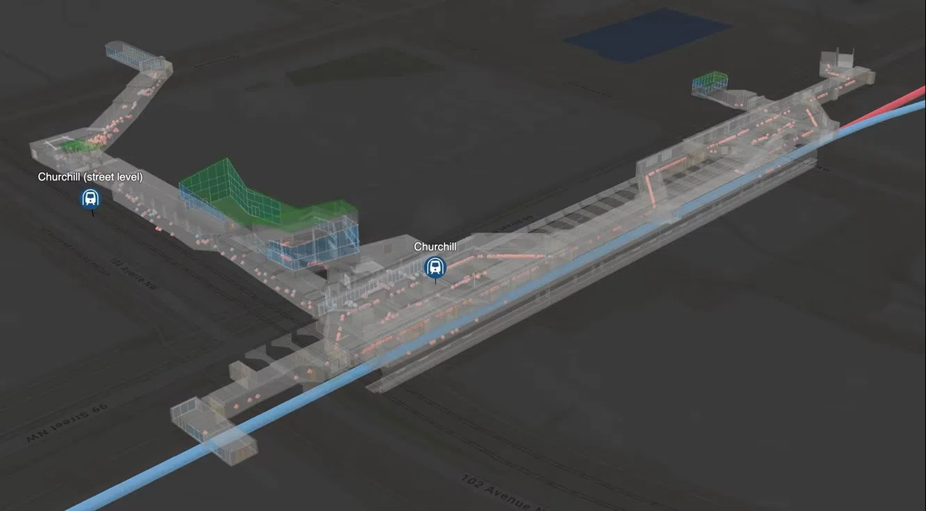
A digital twin of the Churchill station in Edmonton showing recorded positions to support officer tracking and wayfinding within the underground LRT system. Courtesy: Esri Canada
The Edmonton Police Service has partnered with Esri Canada to lead the development of a next-generation community safety system.
The system is powered by Esri’s comprehensive geographic information system (GIS) platform ArcGIS.
The partnership was awarded $1.3 million in federal grant funding to develop the Edmonton Transit Enhanced Community Safety System (ETECS), a pioneering project that will support critical enhancements in officer security and community safety in transit environments in Edmonton and across Canada.
“Everyone deserves a safe and secure transit journey,” said Ron Anderson, Chief Innovation and Technology Officer, Edmonton Police Service.
“With ETECS, we’re leveraging advanced mapping, indoor positioning systems and real-time analytics to transform the ability of our police resources to monitor, plan and respond to incidents, enhancing community safety throughout our transit network.”
The ETECS will improve officer safety and security within the Edmonton Churchill LRT station by creating a digital twin, which allows officers to conduct a 3D walkthrough of the underground station and surrounding pedestrian walkways.
The system also provides officers with location tracking and wayfinding capabilities using Esri’s digital indoor mapping software, ArcGIS Indoors.
Officers can quickly locate themselves and others inside a building or underground in real time through Esri’s indoor positioning system, ArcGIS IPS.
They can also view various data including real-time officer locations and video feeds through dynamic dashboards, improving situational awareness and informing transit policies and community safety measures.
“Knowing what’s happening and where officers are located at any given point in time – above ground and underground, in real time makes a huge difference in public safety,” said Joann Fox, director, Public Safety, Esri Canada.
“Today’s GIS technology provides powerful capabilities to visualize and analyze live data feeds from various sensors, devices and systems and share reliable insights to frontline officers. The work we’re doing on the ETECS project will help Edmonton and many other municipalities across the country strengthen transit safety.”


Comments